How to load data in GeoPandas
Order data for your area of interest in GeoPackage format.
Go to the orders page and download the archive when it’s complete.
Unpack the archive.
Find out a name and a path to the target layer. For example: municipal boundaries (boundary-polygon-lvl6)
Install and import geopandas in Python.
Showing the map:
import geopandas
boundaries = geopandas.read_file("/tmp/data/boundary-polygon-lvl6.shp")
boundaries.plot(column="oktmo")

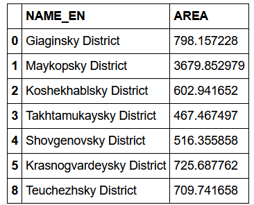
Calculate areas:
boundaries["AREA"] = boundaries.to_crs("EPSG:32637").area / 10 ** 6
boundaries[["NAME_EN", "AREA"]].dropna()